
The Pretty Rivulet: A History of the Ellerbe Watershed
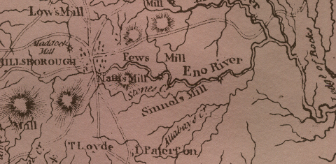
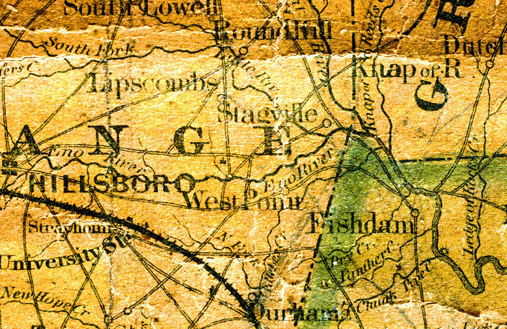
From Allibay and Watery Branch to Pinhook and Allergy Creek, the history of Ellerbe and South Ellerbe creeks is long and colorful. During his 1701 trek through the wilderness of the Carolinas, John Lawson headed east from Occaneechi Town (near what is now Hillsborough). Lawson wrote of hiking 14 difficult miles, "a sad stoney way," to the next village, called Adshusheer.
One local theory holds that Ellerbe Creek might have been "the pretty rivulet" that Lawson crossed -- just south of the Duke family's homestead in Durham County.
In the earliest grants and on the earliest maps, Ellerbe Creek was spelled "Allibay." That spelling led a few scholars to theorize that Ellerbe might be of Native American derivation. When the Europeans arrived, the North Carolina Piedmont was dominated by Sioux-speakers such as the Eno, Occaneechi, Saponi, Sissipahaw, Tutelo, and Shoccoree.
Different European ears heard the Siouxan consonant that had a sound somewhere between an R and an L. Thus, there is much speculation about Ellerbe Creek's oldest name. In the days before standardized orthography, the creek carried a variety of names including, Allibay, Allibay's, Eleby, Ellerbee, Ellerbie, and Ellerbe (we use the state's spelling).
According to the The Colonial Records of North Carolina (1886-90), John Ellerby (Allaby), who received land grants in what is now Anson County, may have first taken up land in present Durham. Historian Jean Anderson opines that Ellerbe Creek took it's name from that family.
In 1737, surveyors traveled up from New Bern looking for "the Enoe fork." The last creek the surveyors found on the west side of the Neuse (before the Eno River) was "Deep Creek." Today, that stream is called Ellerbe Creek.
Before 1752, when this territory was still part of Granville county, some landgrants referred to Ellerbe Creek as "South Eno." In the late 18th century, South Ellerbe Creek was called "Watery Branch."
The oldest landgrants in this area were from the agents of Lord Granville. Almost all of the several hundred Granville grants in old Orange county were on bottom land along the major creeks and rivers (including less than a dozen Granville grants on Ellerbe Creek).
In the early days, settlers avoided the inferior land in the Triassic Basin and gravitated to the richer alluvium of the Haw valley and the upper Eno valley.
Ellerbe Creek-Goose Creek in the Upper-Neuse basin and the New Hope Creek-Mud Creek-Sand Creek- Third Fork Creek in the Cape Fear basin drain most of the Durham portion of a 200-million-year-old sea bed.
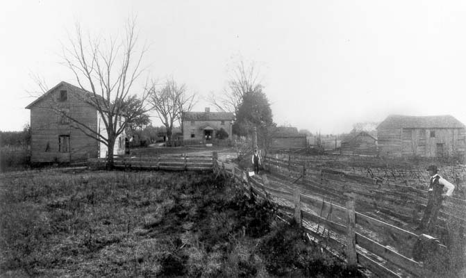
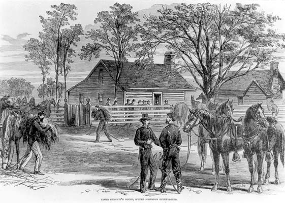
Bennett Place, site of the Civil War's largest troop surrender, is crossed by Ellerbe feeders. James Bennitt's original deed mentions that his land was on "waters of New Hope Creek and Ellerbe Creek," meaning it was on both sides of the ridge that divides the Neuse and Cape Fear watersheds.
Today, the North Carolina Railroad crosses Durham following this ridge. To the north of the tracks, all tributaries including Ellerbe creek and its feeders flow past Raleigh, Smithfield, Goldsboro, Kinston, and New Bern into Pamlico Sound. South of the tracks, the tributaries empty into New Hope Creek -- eventually flowing into the Atlantic below Southport.
The paths of South Ellerbe and Ellerbe follow the history of Durham itself. Several grist mills and saw mills along its banks have disappeared from the records. South Ellerbe was more Blue collar in its origins while Ellerbe held more middle class origins. All these creeks flow through some of the Bull City's most historic urban neighborhoods.
Old West Durham was built for workers in the textile mills, Walltown for workers in the tobacco industry, Watts-Hillandale for shop owners and doctors and, Trinity Park for merchants and teachers at a new college which would eventually changed its name to Duke University.
A number of springs feed a number of little creeks that become South Ellerbe and Ellerbe creeks. Ellerbe Creek begins its course west of Cole Mill Road and crosses Hillandale Golf Course and the neighborhood of Watts-Hospital-Hillandale. When Watts Hospital was moved to Broad Street from Trinity Park, many doctors and merchants built their homes along West Club Boulevard (beginning around 1908).
Ellerbe then flows through areas that were forests and farms until the 1950s. Duke Homestead was one of those farms and is now surrounded by housing developments in what was a large green belt separating Durham and Bragtown.
South Ellerbe´s headwaters rise next to what was once the settlement of Pinhook, which served as a traveler's rest on the dirt road between the colonial capital of Hillsborough and and the new state capital of Raleigh.
In 1906, W.S Lockhart wrote that Pinhook was, "known as a place of brawls and rough-and-tumble fights, drinking, gambling and other forms of amusement, where the natives and visitors met to have a rough, roaring, and to them, glorious time."
Beginning near Greystone Baptist on Hillsborough Road, South Ellerbe Creek flows for three miles through some of Durham's oldest and most densely developed neighborhoods.
Today, the first mile of the creek is surrounded by various auto and muffler shops, large surface parking lots, a plumbing shop, funeral home, photo studio, small apartment complex, the Southern Railroad, Highway 70/Business, a Duke warehouse, an old gas station, and a number of quiet back yards. Its path will take it past three schools: EK Powe Elementary, Brogden Middle and Club Boulevard Elementary.
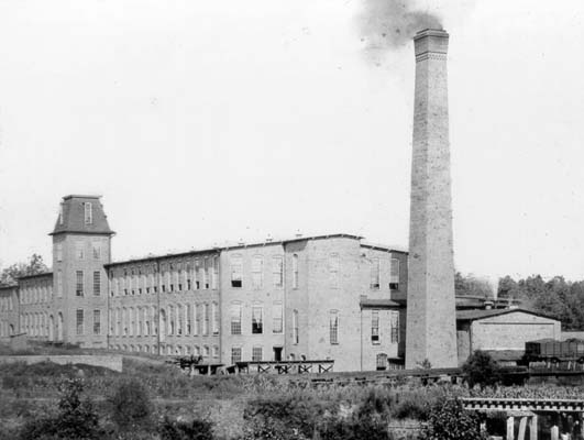
In 1892, the Rigsbee family sold a northern stretch of its farm to make room for the Erwin Mills and some of the surrounding mill village near Ninth Street. Also in 1892, Trinity College moved next door -- to Blackwell's Fairgrounds (eventually becoming Duke's East Campus).
25 years later, the rest of the Rigsbee farm was sold and became Duke's West Campus. Duke's football stadium was built in the ravine where the Rigsbee's kept their pigs (site of the 1942 Rose Bowl, moved to Durham after Pearl Harbor). Many of the Italian stonecutters who built Duke Chapel and the hospital lived in West Durham, near South Ellerbe.
Crossing the northern edge of the old Erwin Cotton Mills, South Ellerbe Creek was channelized and used to dump warm dyes from the mills. At the dawn of the new millennium, many of the mill families still in Old West Durham simply call it the "ditch."
Long-time residents of the mill village recall that a sawmill was placed in the middle of the woods to cut the planks to build the first mill houses -- along the creek. In the early days, the entire neighborhood smelled like a Laundromat -- from the hot, soapy water being discharged by the textile mills into South Ellerbe.
Hall of Fame and Grammy-award winning composer John D. Loudermilk (who wrote 'Tobacco Road') grew up on the banks of South Ellerbe. During the Prohibition, a house on Virgie Street was one of the most popular destinations in all of West Durham. In the back yard were two doors. One was prominent and led nowhere. A second was small and mostly hidden. Visitors would pass through the smaller door to enter a large room filled with floor-to-ceiling cabinets -- each with a small padlock. Inside the private cabinets was a collection of favorite spirits.
According to long-time residents, White Lightning was the brew of choice. Consumption only allowed off-site. One resident recalls a scandalous morning in the 1930s when a body was found in South Ellerbe Creek across the street. Scared the neighborhood kids half to death. Turns out he was fine -- just an avid consumer of local moonshine. Today, this area forms the heart of the National Registry Historic District in Old West Durham and the proposed site for an urban green space.
In the late 1880s, a young African-American man named George Wall followed his job with Trinity College to Durham. Wall bought a wooded plot of land just north of what is now East Campus. Walltown became a neighborhood for workers moving into the Bull City for the growing tobacco industry. The narrow shotgun houses and small residences provided easy access to the tobacco factories. The east-west streets were numbered and the north-south streets were lettered (which explains why Ninth Street is called Ninth Street).
From Walltown, South Ellerbe Creek flows under Guess Road, the massive surface parking lots at Northgate Mall, and Interstate 85. According to the Durham Architectural and Historic Inventory, rapid growth during the 1950s, transformed the forests and farmlands into neighborhoods like Northgate Park.
Another branch of South Ellerbe flows north from downtown through Old North Durham and Trinity Park --joining its sister streams near West Club Blvd Elementary. After emerging from the downtown tobacco warehouse district, the creek passes the old Pearl Cotton Mills site. Cottages from the mill village can still be see where South Ellerbe crosses under Trinity Avenue.
Although many of Trinity Park's early settlers were connected with Trinity College, the majority were merchants, businessmen and professionals. In contrast to Durham's late 19th-century neighborhoods, a smaller proportion of Old North Durham and Trinity Park's residents were directly associated with tobacco and textiles. They were part of the broader local economy produced by their families' successes in Durham's leading industries. These younger generations chose not to live in the older neighborhoods where they grew up close to Durham's industries.
Standing along this branch of South Ellerbe are the Durham Athletic Park (South Ellerbe flows under the pitcher's mound), Durham Central Park (bisected by the creek), Pearl Mills, and the South Ellerbe bike trail (which will eventually become part of the "urban Appalachian Trail" – a bike path connecting towns from Maine to Florida).
The three branches join forces near Northgate Park and flow east, past the Avondale Road K-Mart, Camden Avenue asphalt plant and the old City dump. Near the dump, Ellerbe Creek was channelized, chocked with industrial effluent and leachate (which one writer has called "garbage juice"). At the turn of the last century, the local wags were already calling it "Allergy Creek" (from Ernest Seaman's novel, "American Gold").
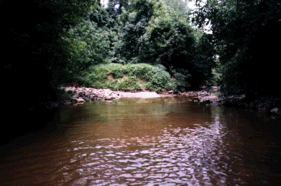
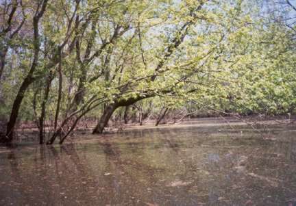
Ellerbe´s last miles are its most serene as it flows along a quiet stretch of bent trees and into Falls Lake at an old wooden railroad bridge (less than a mile south of where the Eno River flows into the lake).
(written by John Schelp, Friends of South Ellerbe, with special thanks to David Southern for his contributions on the early history of Ellerbe Creek)
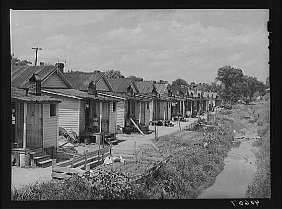
"In 50 years, Durham had spread rapidly from a village to a bustling factory center, sucking in the rolling pine country around it. Shacks for factory workers mushroomed in the lowlands between the graded streets. The little communities, which clung precariously to the banks of streams or sat crazily on washed out gullies and were held together by cowpaths or rutted wagon tracks, were called the Bottoms. It was as if the town had swallowed more than it could hold and had regurgitated, for the Bottoms was an odorous conglomeration of trash piles, garbage dumps, cow stalls, pigpens and crowded humanity ...." -Pauli Murray ("Proud Shoes: The Story of an American Family")
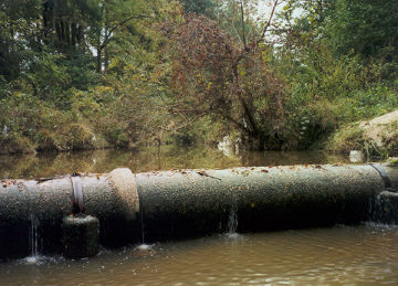
Old
pipe carries 'garbage juice' across Ellerbee Creek.
"The city is built on a low ridge which serves as a watershed between the Eno and the Neuse on the north, and New Hope creek, which is a tributary of the Cape Fear, on the south. As might be expected the soil is poor and unsuited to the cultivation of most crops that a pioneer would be likely to raise. So a student is likely to conclude that in the early settlement of the country this section would not be taken up by the first settlers. The more fertile tracts along the New Hope on the south and the Eno and Neuse on the west and north attracted the new home-seekers and the land lying between them was for some time left vacant. Later on, when the settlements became more thickly populated, the shiftless were pushed out of the fertile acres and came into this poor section of country and built themselves homes. As all know, the shiftless and poor are liable to give way to the less refined forms of vice and we find the people of this section no exception to the rule." -W.S Lockhart (The Settlement of Pinhook, Trinity Archive, 1906) |
Ellerbe Creek Watershed
Association
http://www.ellerbecreek.org